|
|
Post by auntym on Jan 29, 2012 12:47:21 GMT -6
FOX5 News: Strange Clouds and Shadows in the Sky - Jan. 26, 2012 [/color] Uploaded by Sheilaaliens on Jan 28, 2012 "WASHINGTON (D.C.) - Today's Ask the Weather Guys question comes from Jenn Jurek in Fredericksburg. She writes, "I need some answers on some very strange clouds I have been seeing outside my home in the past two months." she says she has read some crazy theories but just wants somebody to tell her what it is!" www.myfoxdc.com/dpp/weather/weather_guy/weather-guys-strange-clouds-01... |
|
|
|
Post by paulette on Jan 29, 2012 13:03:46 GMT -6
Wow! New format. reply at top of screen. Cool clouds and I myself would wonder if a com trail didn't have something to do with this. Forming above the macarel clouds and "laying" on top of them.
|
|
|
|
Post by skywalker on Jan 29, 2012 21:46:32 GMT -6
I disagree with that crazy explanation the weather dude gave about the sun's rays causing it. There are two reasons why. The first is because the shadow is bent slightly as it gets close to the bottom of the picture. Rays from the sun don't bend. The other reason is because it looks to me like the clouds in the shadow are angled slightly different than the surrounding clouds. The lighter clouds seem to be slanted up from left to right while the clouds in the shadow seem to dip down slightly to the right. What I would guess is that there is a slight high pressure ridge there that is causing the clouds in that shadowy area to lift up slightly higher than the surrounding clouds and that is what is causing the shadow...because the sunlight is being blocked by the clouds on either side. Of course that is just a guess and it would depend on which direction the sun was shining from and what time of day it was. My second guess would be what Paulette said about a contrail being up above the clouds. If the sun were shining straight down and a contrail was up above the lower clouds it could theoretically cast a shadow like that. that sounds like a good explanation too. Much better than the lame explanation the weather dude gave.  |
|
Deleted
Deleted Member
Posts: 0
|
Post by Deleted on Jan 30, 2012 2:46:50 GMT -6
The first thing I thought of before I watched the video was that it may be the shadow of a mountain in the distance. Ive seen them cause this effect before but its hard to say.
|
|
|
|
Post by lois on Jan 30, 2012 16:43:05 GMT -6
These exact same clouds were over Cape Girardeau, Mo. Christmas, I even photographed them. No one in the family seen them, but were in aw of it. Somehow those pics got deleted. It was so strange, they were over head for hours. There was hardly any blue in the sky for the ripples I called them. I just brushed it off as weird weather.
|
|
|
|
Post by auntym on Feb 7, 2012 14:13:49 GMT -6
www.huffingtonpost.com/2012/02/07/strange-clouds-florida-beach_n_1259865.html?1328630251
Strange Clouds Form Over Panama City Beach, Florida [/color] ... Published on Feb 7, 2012 by CNN An unusual cloud formation hovered over Panama City, Florida.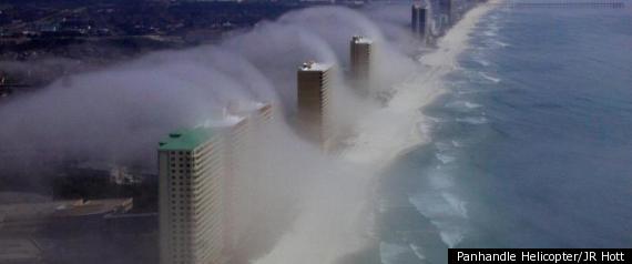 A tidal wave of cotton filling? Some ghostly aerodynamics? A photo of mysterious cloud formations in Panama City Beach, Florida, has the weather world buzzing. Pilot JR Hott of Panhandle Helicopters snapped the spectacular shot, which shows low-lying clouds streaming ominously over high-rise buildings standing sentinel against the Gulf of Mexico. The retired Navy diver, who has owned Panhandle four three and a half years, said he had no idea when he snapped the photo it would demand worldwide attention from the likes of CNN. "I took and I thought it was really cool, so I put it on Facebook," Hott said, attributing the phenomenon to orographic lift -- something usually seen with fog on mountains. "We see it a few times a year, and it can happen in a minute." According to the Weather Channel's Dr. Greg Forbes, it's just a matter of, well, weather. "The relative humidity must have been very high just offshore, almost ready for fog to form anyway," said Dr. Forbes. "Because the clouds form so low down, and then they really get thick, almost obscuring the high-rises. "The other thing that's happening is with friction, the air slows down as it just begins to move onshore. That gives it a little extra convergence and an upward forcing of the air to rise. But it must be that relative humidity needing to be just right that...explains why we don't see this kind of a picture every day." CONTINUE READING: www.huffingtonpost.com/2012/02/07/strange-clouds-florida-beach_n_1259865.html?1328630251
|
|
|
|
Post by auntym on Feb 10, 2012 13:05:05 GMT -6
www.mirror.co.uk/news/world-news/holy-smoke-epic-florida-fog-679565?utm_source=twitterfeed&utm_medium=twitter9 Feb 2012
Holy smoke! Epic Florida fog clouds make for incredible, tsunami-like cinematic sight[/color] Awesome weather formations quickly snapped by helicopter pilot By Rob Leigh   Looking like the megatsunami moment from sci-fi disaster flick Deep Impact, these startling pics are thankfully not chronicling imminent catastrophe for the residents of Panama City. Rather, they record the progress of a far less devastating Act of God as waves of thick fog prepare to engulf the Floridan city. The sweeping murkiness was captured by helicopter pilot J.R. Hott after he was told about the paannamic view by a colleague returning from a flight on Sunday. Determined to snap the low-lying clouds of fog clouds, he made a hasty journey upwards to get as good a vantage point as possible. “We jumped into a helicopter and took off,” he said. “Within a few minutes after we landed, it covered up the helipad.”
CONTINUE READING: www.mirror.co.uk/news/world-news/holy-smoke-epic-florida-fog-679565?utm_source=twitterfeed&utm_medium=twitter
|
|
|
|
Post by auntym on Mar 1, 2012 12:53:06 GMT -6
cnufos.ning.com/profiles/blogs/scientists-warn-clouds-are-descendingSCIENTISTS WARN: CLOUDS ARE DESCENDING * Posted by Cnufos on March 1, 2012 Worldwide scientists have noted that clouds are getting lower than before. The average height of clouds has fallen significantly in recent years, though they are not dropping significantly enough without reason. Is this descent in clouds related to recent activity from the sun? Could this effect have something to do with the fact that this is 2012? Or is this new global development explained a bit more simply?  The discovery, originally made by researchers working at the University of Auckland, shows that data from the Multi-angle Imaging SpectroRadiometer has clocked the average height of clouds as up to 130 feet lower on average than ten years ago. MISR, the satellite responsible for the measurements has a few climatologists scratching their heads in wonder. While scientists have offered to apply the new data to better improve their climate models, there is no proof that this process will be able to explain why the clouds are descending in the first place. One of the problems of low clouds is the fact that as they descend, they radiate less heat than they would if they were high up from the surface of the Earth. High up large clouds are one of the many countermeasures to have an effect on Global Warming, as they reflect heat and light up off of the Earth's surface. Low clouds mean more light and heat is being reflected much closer to Earth and must pass through far more atmosphere to be radiated back into space. This in turn reflects more back to the surface where it must be either absorbed or reflected back into the atmosphere. Of course the true impact on Global Warming will have to be determined by scientists when they input the new data into future global weather simulations.
CONTINUE READING: cnufos.ning.com/profiles/blogs/scientists-warn-clouds-are-descending
|
|
Deleted
Deleted Member
Posts: 0
|
Post by Deleted on Mar 1, 2012 17:23:55 GMT -6
Funny you should mention low clouds my daughter mentioned just last night our clouds were really low. Hmmm have to watch this one  |
|
|
|
Post by lois on Mar 1, 2012 21:34:59 GMT -6
I noticed that last summer. Last summer my trip to cape they were very low. Time will tell .. if this gets worse.
|
|
|
|
Post by paulette on Mar 1, 2012 23:59:27 GMT -6
Last year I was driving along a highway with trees on both sides, low mountains on the other and in front of me, in the road there was little a little wispy white tornado of a cloud that was forming and rising. I had never seen anything like that before.
|
|
|
|
Post by auntym on Jul 25, 2012 1:31:20 GMT -6
www.huffingtonpost.com/2012/07/23/batman-shooting-picture-o_n_1696545.html?icid=maing-grid7
Batman Shooting: Picture Of Clouds Over Movie Theater After Vigil Said To Look Like An Angel (PHOTO)Posted: 07/23/2012 After a vigil held near the Aurora movie theater, Crystal Fuller snapped a photo of some clouds gathered above the theater that she believes looks like an angel. Fuller wrote on Facebook: I took this picture last night after I left the vigil....Looks like an Angel in the clouds above Century 16. Touching! Crystal posted the photo on the 7News Facebook page and the picture had already garnered hundreds of comments and more than 1,000 shares. 7News reports that Fuller took the photo the night of the vigil, but didn't notice the shape of the clouds resembled an angel until a friend pointed it out to her. If you are interested in supporting victims and families of the Aurora movie theater shooting, visit GivingFirst.org.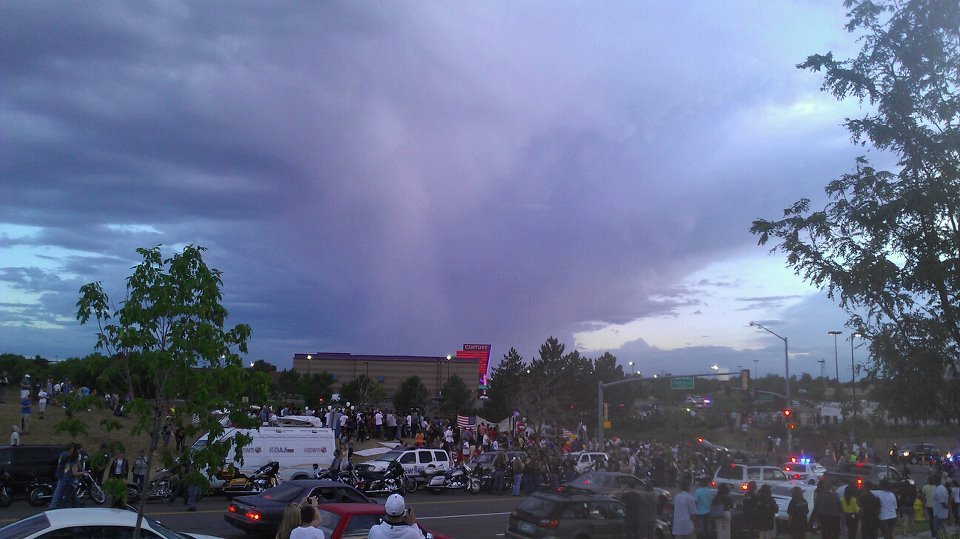
|
|
Deleted
Deleted Member
Posts: 0
|
Post by Deleted on Jul 25, 2012 1:32:52 GMT -6
This image was taken with a digital camera. Shapes like that often show up while I'm using my cell phone's camera function... it is kinda cool looking though...  |
|
|
|
Post by auntym on Jul 25, 2012 1:37:10 GMT -6
it does have an angel shape.... i believe in angels...  |
|
Deleted
Deleted Member
Posts: 0
|
Post by Deleted on Jul 25, 2012 1:38:06 GMT -6
One never knows... it could very well be an angel...
|
|
Deleted
Deleted Member
Posts: 0
|
Post by Deleted on Jul 25, 2012 12:05:58 GMT -6
Never know..I have this feeling deep inside..a memory somehow..of spreading my arms and moving on the wind. I know what that feels like...somehow. It's impossible to say..what memories we may carry from long ago times. I just know..that I know how it feels to spread myself on the wind and let it carry me.  |
|
|
|
Post by swamprat on Aug 14, 2012 20:44:30 GMT -6
Scary cloud! By 1anthem | Posted August 13, 2012  CNN PRODUCER NOTE 1anthem saw the cloud that looked 'like a twisted sausage' and was scared a tornado was coming. CNN senior meteorologist Brandon Miller tells us it was likely an Arcus, or roll cloud -- a fairly rare type of cloud 'usually formed on outflows from storms or cold fronts.' Roll clouds are harmless, although they can look ominous, he said. CNN PRODUCER NOTE 1anthem saw the cloud that looked 'like a twisted sausage' and was scared a tornado was coming. CNN senior meteorologist Brandon Miller tells us it was likely an Arcus, or roll cloud -- a fairly rare type of cloud 'usually formed on outflows from storms or cold fronts.' Roll clouds are harmless, although they can look ominous, he said.
- dsashin, CNN iReport producer Traveling back home from Ohio to Michigan I noticed this scary cloud. Images were taken on August 13, 2012 , Ohio turnpike area. ireport.cnn.com/docs/DOC-828560?hpt=hp_bn1
|
|
|
|
Post by auntym on Aug 26, 2012 12:14:28 GMT -6
Published on Aug 25, 2012 by UFO HuntingClouds This is a crazy sunset over Arizona on August 20, 2012. The sunset looked out of this world. Help me find the UFO. There is so much UFO activity in Arizona that I need another set of eyes to check out the videos for me. This is the morning after clouds of yesterdays monsoon storm near Phoenix Arizona. Let me know if you see anything and if you do leave a comment or send me a DM with the time that you have seen the UFO and approximately the location (top right, left) wherever. Thanks for your help and happy UFO hunting! Be sure to check out the UFO sightings blog at ufosightingz.blogspot.com |
|
Deleted
Deleted Member
Posts: 0
|
Post by Deleted on Aug 26, 2012 12:24:41 GMT -6
I think it m may just be a spectacular sunset  |
|
|
|
Post by plutronus on Dec 31, 2012 2:47:33 GMT -6
Hello All,
Not quite sure where to post this?
A friend of mine who's an amateur photographer, and has a minor interest in subjects UFO/ET, I suspect mainly through association with me? Over the years, donated various gadgets to aid my ET field-experiments, --several PCs, a nice laptop and a 2nd Gen StarLight-Scope. No stranger to ET subjects.
Dec 28, 2012, my friend in e-letter to me regarding the photo said:
"I was at Office Depot at Parthenia & Corbin (just outside Mr. Stuff/Brent's Deli pointing about 10 degrees West of North) at about 14:00 PDT (2pm) when the pic was taken, and by 16:30 ~ 17:00 PDT (4:30-5pm) the clouds had significantly disintegrated, same position and all, when viewed from Del Taco at Chatsworth and Zelzah in the North Valley. Sky was a curious sort of paannama of what looked like cotton ball clouds and a slight rainbow around the sun, very interesting. "
FYI,
plutronus
Attachments:
|
|
|
|
Post by skywalker on Dec 31, 2012 8:34:35 GMT -6
The two explanations I have heard for how those formations might occur are either from what they call a "punch hole" when an aircraft flying at supersonic speeds creates a sonic boom which blasts a hole through the clouds, or it is the result of the formation of ice crystals in the upper clouds which then fall down and break through the lower clouds creating a circular hole. That's what the scientist type people are saying any way.  |
|
|
|
Post by lois on Jan 1, 2013 22:25:19 GMT -6
The two explanations I have heard for how those formations might occur are either from what they call a "punch hole" when an aircraft flying at supersonic speeds creates a sonic boom which blasts a hole through the clouds, or it is the result of the formation of ice crystals in the upper clouds which then fall down and break through the lower clouds creating a circular hole. That's what the scientist type people are saying any way.  Or a ufo traveling at super sonic speed.  I'm taking my camera out. Those aliens love light displays.  |
|
Deleted
Deleted Member
Posts: 0
|
Post by Deleted on Jan 2, 2013 16:42:43 GMT -6
The aeronautical engineer/pilot friend of mine says they are from ice layers in the clouds..we had some over our neck of the woods the other day when it was very cold. Air..exists in 3 forms...gas, liquid and solid. As a solid it exists in ice when frozen and in liquid form which we use in many ways and we are familiar with. In air, it is present in gas form which is also known as vapor.  |
|
|
|
Post by plutronus on Jan 3, 2013 2:41:48 GMT -6
Hello All,
Not quite sure where to post this?
.
.
<<deletia>>
.
.
Dec 28, 2012, my friend in e-letter to me regarding the photo said:
"I was at Office Depot at Parthenia & Corbin (just outside Mr. Stuff/Brent's Deli pointing about 10 degrees West of North) at about 14:00 PDT (2pm) when the pic was taken, and by 16:30 ~ 17:00 PDT (4:30-5pm) the clouds had significantly disintegrated, same position and all, when viewed from Del Taco at Chatsworth and Zelzah in the North Valley. Sky was a curious sort of paannama of what looked like cotton ball clouds and a slight rainbow around the sun, very interesting. "
FYI,
plutronus
Apparently, this cloud formation is a fairly unusual cloud formation as there are two of them side by side. This may be the only photo in existence of two fallstreak clouds that formed simultaneously. There are a few theories about how these fallstreak clouds or as some laymen name them, 'hole-punch' clouds, form. All of the formation theories remain controversial, meaning that meteorologists don't know exactly how they form, but they have proposed some working theories. I sent the photograph to a meteorologist who works for the NOAA. I'll keep all abreast as info becomes available (if any?). As this fallstreak event transpired over a major city, the NOAA scientists have access to good environmental metrology information, plus the time, location and area of the event. They are excited about the formation due to its side-by-side replication and also the presence of the alto-cannellus cloud (the thermal occlusion 'line break' which is in the mackrel-cumulus), all of which are unusual, as they have not been seen to form together. Anyway, I've included a few photo-links of other similar 'fallstreak' cloud formations for your perusal: Cloud Appreciation Society - Fallstreak Holes cloudappreciationsociety.org/74/icons-ak.wunderground.com/data/wximagenew/p/pcbman/137.jpgwww.environmentalgraffiti.com/meteorology/news-10-most-incredible-hole-punch-cloudsplutronus |
|
|
|
Post by plutronus on Jan 3, 2013 2:51:34 GMT -6
The aeronautical engineer/pilot friend of mine says they are from ice layers in the clouds..we had some over our neck of the woods the other day when it was very cold. Air..exists in 3 forms...gas, liquid and solid. As a solid it exists in ice when frozen and in liquid form which we use in many ways and we are familiar with. In air, it is present in gas form which is also known as vapor. 
plutronus |
|
|
|
Post by skywalker on Jan 3, 2013 8:19:19 GMT -6
I think she meant to say water instead of air.
|
|
Deleted
Deleted Member
Posts: 0
|
Post by Deleted on Jan 3, 2013 12:50:15 GMT -6
Actually..I was leaving out an entire word..it's how WATER exists in the AIR in three forms..one being a gas. There's a lot about our own world people don't know...and they're busily hunting creatures from others.. When they do see something earthly spectacular like lenticular clouds..it's got to be something caused by a UFO. I don't get that.  search.yahoo.com/search?ei=UTF-8&fr=crmas&p=lenticular+clouds search.yahoo.com/search?ei=UTF-8&fr=crmas&p=lenticular+clouds |
|
|
|
Post by auntym on Jan 5, 2013 16:22:54 GMT -6
whofortedblog.com/2013/01/04/incredible-double-helix-dna-cloud-appears-moscow/
Incredible “Double Helix DNA Cloud” Appears In the Moscow Sky[/color] January 4, 2013 Greg Newkirk Watchful Moscow residents with their eyes to the sky were given an interesting view on Christmas Eve, as a huge “celestial spiral” closely resembling a strand of DNA appeared over the city. In a batch of photos posted to the photo sharing session of Russian website Netall.ru, one of the strangest cloud formations ever is detailed in a handful of images snapped around a 20 mile stretch of the city. As you can imagine, this has stirred up some interesting conversation as to what could be the cause of such an event. As of now, sky-savvy internet sleuths believe the strange clouds were caused by contrails, or thin artificial cloud formations caused by the water exhaust emitted from aircraft. You’ve more than likely seen them in the sky on a regular basis, but rarely in such a striking form. We’re not saying it was aliens, but well.. you know.  SEE MORE PICTURES: whofortedblog.com/2013/01/04/incredible-double-helix-dna-cloud-appears-moscow/ SEE MORE PICTURES: whofortedblog.com/2013/01/04/incredible-double-helix-dna-cloud-appears-moscow/
|
|
|
|
Post by auntym on Jan 15, 2013 14:38:03 GMT -6
www.stumbleupon.com/su/1sGIt3/matadornetwork.com/bnt/60-insane-cloud-formations-from-around-the-world-pics/?utm_source=Twitter&utm_medium=Article&utm_campaign=SocialMedia
60 insane cloud formations from around the world [PICs]
By Hal Amen On July 25, 2012 Cloud varieties go way beyond the cumulus, stratus, and cirrus we learn about in elementary school. Check out these wild natural phenomena. STANDING IN A CORNFIELD IN INDIANA, I once saw a fat roll cloud (like #4 below) float directly over my head. It’s a 12-year-old memory that remains fresh. There was a moment of mild panic just as the cloud reached me — Is this what a tornado looks like right before it hits? I thought. This is some freaky unnatural *bleep* and I do not know how I’m supposed to react. I imagine a lot of these photographers having similar hesitations as they set up for the shots below. While it was relatively easy to put together this collection due to the huge number of crazy cloud pictures available online (did you know there’s a Cloud Appreciation Society?), many of the phenomena shown here are pretty rare…and potentially panic-inducing. 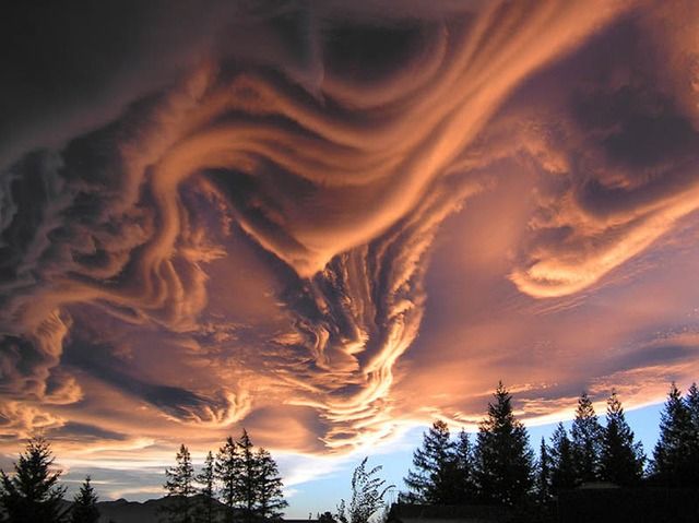 Photo: wittap 3. Asperatus formation, Canterbury, New Zealand This one’s so rare it doesn’t even have official classification. “Undulatus asperatus” is its proposed designation, and if accepted as a new form by meteorologists, it’ll be the first such addition since 1951. As of now, it’s just another example of New Zealand having the coolest freakin’ landscapes. 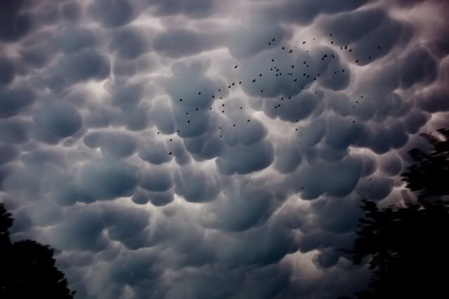 Photo: Lars Plougmann 2. Mammatus clouds, Ft. Worth, TX Another rare and easily recognizable variety, mammatocumulus tend to spill out from the base of massive thunderheads in a characteristic blanket of pouch-like nodules. Generally a good cue to head indoors. Read more at matadornetwork.com/bnt/60-insane-cloud-formations-from-around-the-world-pics/#4EbCyzlD7fRHgZF8.99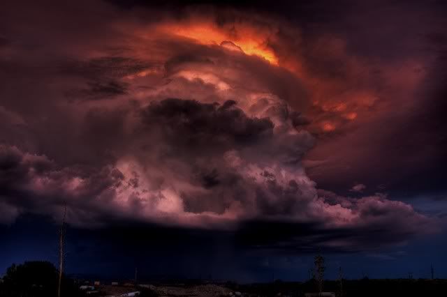 Photo: deansouglass 55. “The Cloud of Darkness,” Silver City, NM This is the name the photographer gave to the massive thunderhead pictured below, which formed over southwestern New Mexico in August of 2007. SEE ALL 60 PHOTOS: www.stumbleupon.com/su/1sGIt3/matadornetwork.com/bnt/60-insane-cloud-formations-from-around-the-world-pics/?utm_source=Twitter&utm_medium=Article&utm_campaign=SocialMedia
|
|
CitizenK
Full Member
   I'm Back Guys!!! I've missed you so much!!!
Posts: 562
|
Post by CitizenK on Jan 16, 2013 0:01:45 GMT -6
Isn't nature awesome!  I love this, thanks M, you always find the coolest stuff! |
|